FOUAD
Fouad is one of the two new salvage excavations in the heart of Alexandria begun in 2000. The dig is situated on the site of the former Greek Orthodox Patriarchate between Saint Saba church and Fouad Street, that is, in the vicinity of the ancient Canopic Way. If one follows Strabo, the ancient street was twice as wide as the modern and one might hope to discover a section of the former, perhaps even the colonnade that ran along its border.
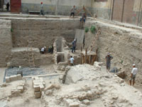
View of the northern sector of the site (June 2001)
The parcel of some 2595 m2 belongs to the Greek Orthodox Patriarchate and was, to the north, occupied by a single storey garage, and to the south by a 19th century construction. This construction, whose upper floors have been destroyed, is still occupied on the ground floor by different shops and businesses. All the rubble from the destruction of the upper storeys had remained in place (2300 m3). Work began in November 1999. In the first instance, there was a concentration on preparing the site for excavation : tearing down of walls next to the dig zone, creation of premises for handling archaeological artefacts, removing rubble etc. The dig proper began in March 2000 in the northern sector of the parcel where the garage once stood.
After the destruction of the concrete flooring of the garage and the filling beneath, an area corresponding to a garden was uncovered. This garden, marked on 19th century maps, was held within the compound of Saint Saba church (still in use today). It covered different landfills, evidence of partial destruction of previous layers and a long period of abandonment. Beneath this there appeared a layer of paved flooring (limestone alternating with fragments of blue or white marble) associated to habitation areas delineated by floors and walls (medieval period). This paving was installed over a network of channels (at least two periods of construction) connected to a cistern.
Two major phases can be distinguished today, separated by an accumulation of layers of rubble, which might hold slight evidence of occupation. The most recent phase, in the north-west/south-west sector of the site, reveals the importance of water management. In effect, on this small section (680 m2) the unearthing of two basins, three cisterns, three wells and two channel systems shows the necessity for the population to supply and stock water. The hydraulic structures play a central role in the layout of the related surrounding structures (habitation and/or workshop units defined by a chalk mortar flooring, a paved area and walls of small blocks). The older phase in the north-east/south-east sector for the moment displays the remains of structures in poor condition. Vestiges of walls, door sills, flooring, and numerous little islands of demolition are the component parts of the upper layer of this phase. Traces of phantom walls related to the other destroyed elements are beginning to appear.
The rich archaeological potential of the site points the lines of research in two directions to be followed in tandem.
- On site it is a question of understanding these vestiges in an overall manner by studying construction techniques, following the orientation of the structures discovered and observing the stratigraphical connections between them. This work will allow for a clearer view of the evolution of public and private constructions and will thereafter, along with results obtained from other neighbouring digs (Lux, Billiardo Palace, Cinema Majestic, Kom el Dikka), contribute to a more pertinent synthesis for the understanding of the urbanism of the district. At this moment, careful excavation is taking place in the eastern sector of the site in order to obtain a coherent plan of the vestiges, whereas in the western sector, the dismantling of the cisterns continues.
- As the excavation continues, the material found on site is being treated, from cleaning to marking to stocking to entering into computer data bases. The creation of premises destined to this effect allows for a daily follow up of the archaeological material uncovered. A data base, up-dated as discoveries appear, eases the gathering and storing of essential information connected to the object (or group of objects): excavation context, category and further eventual precisions, nature and place of storage. This data base, which will be further expanded by future studies undertaken by the different examiners of the material, will itself be linked in the post-excavation stage to the data from the site, thus facilitating a relational presentation of all the elements of the excavation.
The aims of such an excavation
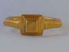
The discovery of sequences of medieval stratigraphy in place (flooring, walls) is already an important element : data corresponding to this period are essentially literary. The discovery of hydraulic structures (cistern, channel network) and their stratigraphical situation will provide more data for the comprehension of Alexandria's water supply system at all periods. The proximity of the Canopic Way lets us hope that, on reaching the Hellenistic levels, we may uncover elements related to this axes. Did Alexandria, a city conceived by Greek planners, mirror other Hellenistic towns or was it the beginnings of a new conception of urban planning? To date, the artefacts found are numerous and from all periods together. Within the collection, one might remark certain remarkable pieces : jasper intaglios, a gold ring, a mosaic fragment and a quantity of medieval ceramics and pipes. The study of the material from undisturbed levels will provide firm datation.
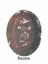
Magic gem
On one face a protecting divinity, on the other, a magical formula
2nd century AD
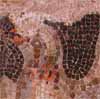
Detail of a floor mosaic depicting a bird
2nd century AD.
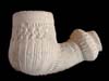
Terra cotta pipe
with ribbing
Ottoman period