|
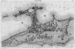
Map of Alexandria (1798)
Description de l'Egypte pl.84 |
|
Archives
CEA - © CEA
|
|
The study of Alexandria's water system 4th century BC to 19th century AD |
| The cisterns of Alexandria | Isabelle Hairy |
| The engineers of Bonaparte's expedition noted in the Description de l'Egypte five underground aqueducts and more than 400 cisterns. Four of the former ran south-north and were fed by the canal, which followed more or less the same line as the present-day Mahmoudieh Canal. The fifth lay perpendicular to the others and ran along the Canopic Way, which corresponds with today's Fouad Street, one major arteries of modern Alexandria. |
|
|
 |
|
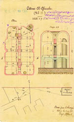
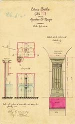
| These remarkable structures point out the importance of the network but the are unfortunately difficult to plot on the modern map of Alexandria. In 1990 only one sole cistern could be visited by the public, El Sahrig el Nabih (see introduction photograph), situated beneath Shallalat Gardens next to the 9th century Toulounid fortifications. |
 |
 |
|
| Today our knowledge of the ancient water supply network is still only partial. The data gathered together in the Kamil files has helped expand that knowledge through an inventory of the cisterns still in use at the end of the 19th century. |