TOPOGRAPHY
Mapping the sea
Latest up-date August 2002
Since October 1996, our excavations and explorations have moved further off shore where numerous amphoras lie, indicating the sites of shipwrecks. From the divers' first investigations it was deemed necessary to map the objects spotted on the seabed.
Working some 400 metres far from the shore, the diver on the surface had to have very sharp eyesight and great concentration to communicate with the topographer. Beyond 600 metres the method previously described was no longer efficient.
Thus we turned to plotting by satellite, a system developed by the United States' Department of Defence but now a standard work tool available to geometers and topographers. A station, capable of receiving and using signals emitted by GPS satellites, can plot the position of any point within the World Geodetic System 1984 (WGS 84). A single station provides an accuracy of less than ten metres.
For topographic and geodesic uses a differential technique is required, employing two GPS receivers: one fixed as a reference, the other mobile. This technique gives an accuracy of around one centimetre.
In April 1995 the CEA acquired a differential GPS (Leica 200 single frequency) and benefited over 18 months from a loan by Leica of another model (300 system, bifrequency, real time).
The fixed station receiver is set up on a known reference point within Fort Qaitbay and the mobile receiver is taken onboard a Zodiac dinghy. The "real time" GPS model has the added facility, thanks to the two radio modems coupled to the receiver, of being able to instantly obtain the co-ordinates of a point either in the world network or within our local work system. The principal advantage of the GPS is that one can plot distant points. At the same time, however, it cannot bypass the problems posed by sea swell or current.

The fixed GPS receiver is set up on a known reference point
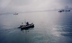
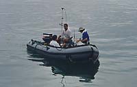
Plotting the shipwrecks: the GPS antenna is loaded onboard the rubber dinghy. Photos - CEA/Jean-Yves Empereur, 1996 - © CEA