TOPOGRAPHY
Mapping the sea
Latest up-date August 2002
The underwater site off Qaitbay Fort
For the underwater excavation of the site off Qaitbay Fort, the topography department had to plot the positions of the sunken ancient blocks. During the first major campaign in 1995, a new system was developed between the divers and the topographers. A buoy, to which is attached a reflective prism often used for long distance measuring, floats on the surface of the sea. This is in turn connected to an adjustable cord bearing a 35-kilo weight at the end of which is a sort of pointer. Under the water a diver positions the pointer upon the point to be plotted (corner of a block, a fixed metal picket, etc.). He adjusts the cord so that the buoy is vertically above the point. The topographer on shore takes the measurement with an electronic theodolite. Simple but clear and precise hand gestures allowed the team to communicate.
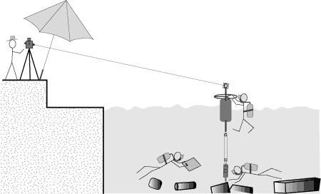
Plotting the ancient blocks on the underwater site at Qaitbay.Direct sighting Drawing by Nelly Martin (1997) - © CEA
This system is limited by the effects of the swell, which causes the buoy to move on the surface, the current that can stop the cord from being vertical and, lastly, the distance between the theodolite and the buoy. Thus we could only employ this method close to the shore when the sea was calm.
The map of the ancient sunken blocks off Qaitbay has thus been created since 1994. As of 30 September 2001, there are no less than 2535 blocks plotted.
Since June 2001 the divers have at their disposal a new tool for underwater measurements: the D100 aquameter. This acoustic system allows for the registering of the relative co-ordinates between a fixed receiver base and a hand-held pointer-emitter. Never the less, the topography team are still required to plot the position of the base receiver and the reference points within the general co-ordinate system.
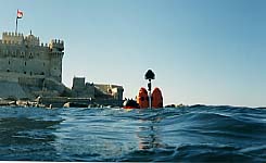
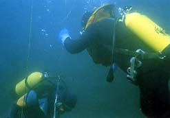
At the surface a diver holds the buoy; underwater two divers set the pointer upon a block.
Photos CEA - Alain Lecler - 1994 © CEA