TOPOGRAPHY
Mapping the land
Latest up-date August 2002
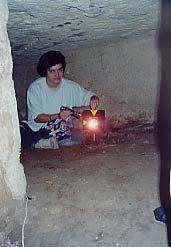
The topography department of the CEA draws up a plan of the sites excavated by the CEA, plotting the archaeological vestiges as they are slowly brought to light. This plan is of fundamental use in a dig. It serves as the reference document that allows the archaeologist to situate precisely all the elements discovered (walls, paving, skeletons, amphoras, etc.), to have an archive of the data irreversibly destroyed as the dig progresses, and to be able to understand the globality of the site. The points plotted are calculated in a three dimesional Cartesian framework covering the entirety of the site. The different levels uncovered can be superimposed thanks to this system. Depending on the layout of the site, the time alloted for the survey and the precision required, we use different tools - from the most basic (tape measure, plumb line ) to the most sophisticated, such as satellite location with a Global Positionning System (GPS). The principal tool of the topographer remains the electronic tacheometer (a theodolite that measures horizontal and vertical angles, to which is integrated an infra-red distancemeter). The plans are generally drawn up to a scale of 1/50 directly on the computer, printed out on a tracer and then made available to the archaeologists. The table below presents the number of points plotted on the main archaeological excavations in the center of town.
| Site | Area excavated | Intervention of the topography department | Number of points plotted |
| Former Diana Theatre | 950 m2 | January to November 1997 | 8500 |
| Garden of the former British Consulate | 1930 m2 | January to May 1997 | 6500 |
| Former Cricket Ground | 975 m2 | May to June 1997 | 2500 |
| Gabbari | 3920 m2 | June 1997 to February 2000 | 19000 |
| Gharaba | 900 m2 | December 2000 to January 2001 | 500 |
| Fouad | 700 m2 | November 1999 till today | 2200 |
| Lux | 2000 m2 | June 1999 till today | 1500 |
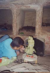
Surveying a tomb in the Gabbari Necropolis (1997)
Photos CEA, Nelly Martin, Hassan Ali